New York -- before the City | Eric Sanderson
The Mannahatta Project: Rediscovering New York's Lost Landscape
Introduction to the Concept
- The speaker introduces the idea of exploring unseen aspects of cities, particularly New York City, through literary references.
- Cites F. Scott Fitzgerald to evoke a sense of nostalgia and connection to the past, emphasizing the beauty of what once was.
- Introduces "The Mannahatta Project," aimed at rediscovering New York's ecological history as it existed in 1609 when Henry Hudson arrived.
Act I: A Map Found
- The speaker shares personal background growing up in the Sierra Nevada Mountains, which fostered a love for landscapes and ecology.
- Discusses his career with the Wildlife Conservation Society and extensive travels observing wildlife globally while returning to NYC on weekends.
- Reflects on experiences in iconic NYC locations like Times Square and Central Park, questioning how these urban landscapes support local ecosystems.
Historical Context and Exploration
- The speaker notes that NYC became the first mega-city with over 10 million people by 1950, prompting curiosity about its historical geography.
- Describes paintings depicting historical views of NYC, highlighting changes over time and his quest to find specific locations mentioned in art from earlier centuries.
- Discovers a significant map from British military cartographers during the American Revolution that reveals lost features of Manhattan’s landscape.
Georeferencing Historical Maps
- The map is described as large (10 feet long) and detailed, showing early geographical features such as Collect Pond and Lispenard Meadows that have since disappeared.
- Emphasizes that this map served both military purposes and ecological interests by documenting natural features alongside urban development efforts.
- Explains plans to georeference this historical map against modern city layouts to uncover lost ecological elements within contemporary geography.
Ecological Fundamentals
- The speaker envisions stripping away modern streets and buildings from the historical map to reveal foundational ecological elements like hills, streams, and shorelines.
Ecological Landscape and Native American Habitats
Mapping the Ecological Aspects
- The ecological landscape is defined by various maps, including geology, soil types (17 classes), and digital elevation models that help calculate slopes and winter wind exposure.
- A probability map was created to identify potential locations of Native American settlements, particularly the Lenape, based on environmental factors like proximity to water and protection from winter winds.
Understanding Human Sustainability
- Red areas on the map indicate optimal human sustainability zones in Manhattan, highlighting areas near water sources and protected from harsh weather conditions.
- The Lenape practiced horticulture with "Three Sisters" gardens (corn, beans, squash), leading to a model predicting where these fields might have existed historically.
Biodiversity in Manhattan
- Manhattan had 55 distinct ecosystem types—more per acre than renowned parks like Yosemite or Yellowstone—indicating a rich biodiversity capable of supporting various species.
- Research included studying local fauna such as fish, frogs, birds, and historical species like Heath hens and black bears to understand their habitat needs.
Habitat Relationships
- Habitat mapping focused on essential resources for wildlife: food, water, shelter, and reproductive sites; this intersection defines both ecological habitats and human homes.
- Specific requirements for different species were documented (e.g., beavers need streams with certain trees), revealing interconnected habitat relationships among species.
Muir Web Concept
- The concept of a "Muir Web" emerged to visualize connections between species and their habitats across Manhattan's ecology.
- This network illustrates how various plants and animals depend on each other for survival while also linking back to geological features over time.
Visualizing Historical Landscapes
- Muir webs were integrated into maps to reconstruct historical landscapes in Manhattan.
- Each point in the web represents different species or environmental elements connected through invisible cords that sustain nature's resilience.
Interactive Exploration of Historical Ecology
- Users can explore historical data about Manhattan’s ecology via an interactive website that reveals what existed 400 years ago at specific locations.
- Advanced visualization techniques were employed to recreate landscapes using topography, soils, watersheds, ecological communities, and species distributions.
Exploring Historical Georeferenced Views of Manhattan
The Power of Visualization
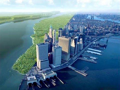
- Utilizing advanced technology, we can create georeferenced views that allow us to visualize Manhattan's landscape as it appeared 400 years ago.
- Examples include views from the East River and Hudson River, showcasing historical landmarks like the Collect Pond and Lispenard Marshes, which were significant to Native American communities.
Historical Context and Modern Connections
- A vivid comparison is made between modern-day locations, such as the New York Court House, and their historical counterparts like the Collect Pond.
- The speaker emphasizes the importance of merging science with visualization to appreciate both past and present landscapes of Manhattan.
Reflections on Diversity and Resilience
- The interconnectedness of Mannahatta (the original name for Manhattan) is highlighted, emphasizing its diversity and resilience—qualities essential for contemporary urban living.
- The speaker draws parallels between past environments and current urban settings, suggesting they reflect each other in terms of natural integration.
Envisioning Future Urban Habitats
- Looking ahead 400 years, cities must cater to human needs: home, food, water, shelter, reproductive resources, and meaning.
- Imagining a transformed Madison Square Park without cars but filled with forests and streams illustrates a vision for sustainable urban design.
Sustainable Urban Development Concepts