Temperatura vs Altitud
Behavior of Temperature with Altitude in the Lower Layers of the Atmosphere
In this section, we will discuss how temperature changes with altitude in the lower layers of the atmosphere, specifically focusing on the troposphere. We will explore the processes that contribute to heating and cooling in these layers.
Temperature Changes in the Troposphere
- The troposphere, being the lowest layer of the atmosphere, is primarily heated by terrestrial radiation emitted from the Earth's surface.
- Solar radiation, consisting of shortwave radiation, is not easily absorbed by atmospheric gases and directly reaches and warms the Earth's surface.
- The Earth's surface also emits longwave radiation known as terrestrial radiation, which is readily absorbed by certain gases in the atmosphere, leading to their warming.
- These heating processes, along with other factors such as heat conduction at the surface and pressure changes with altitude, result in warmer temperatures at lower altitudes and colder temperatures at higher altitudes within the troposphere.
Vertical Temperature Gradient
- The rate at which temperature changes with altitude is described by the vertical temperature gradient.
- For example, if we have a temperature of 20 degrees Celsius at sea level and it decreases to 19 degrees Celsius at 1000 feet above sea level, we can determine that there is a decrease of 1 degree Celsius per 1000 feet. This indicates a vertical temperature gradient of 1 degree Celsius per 1000 feet.
- Similarly, if there is a temperature decrease of 3 degrees Celsius per 1000 feet above sea level, we would have a vertical temperature gradient of 3 degrees Celsius per 1000 feet.
Standard Vertical Temperature Gradient
- In standard atmospheric conditions within the troposphere according to international standards, the vertical temperature gradient is typically around 2 degrees Celsius per 1000 feet.
- This means that the temperature decreases by approximately 2 degrees Celsius for every 1000 feet of altitude gain.
- Starting from a temperature of 15 degrees Celsius at sea level, the temperature would decrease to around -56 degrees Celsius at an altitude of 36,000 feet, where the tropopause marks the transition between the troposphere and the stratosphere.
Isotherms and Realistic Temperature Conditions
- In real-world conditions, atmospheric temperature behavior can deviate from standard conditions. To analyze temperature changes in realistic conditions, isotherms are used as reference lines.
- Isotherms are lines connecting points with equal temperatures and are useful for studying horizontal temperature variations. However, they can also be used to analyze vertical temperature variations.
- The spacing between isotherms indicates the rate of temperature change with altitude. Closer spacing suggests a rapid change in temperature, while wider spacing suggests a slower change.
- Depending on specific conditions and locations, the vertical temperature gradient can vary significantly. In some cases, there may even be isothermal layers where temperatures remain constant with increasing altitude.
Inversions of Temperature
- Inversions occur when there is a layer in which temperatures increase with altitude instead of decreasing.
- There are two types of inversions: surface inversions and aloft inversions.
- Surface inversions extend from the surface to a certain altitude. For example, if there is an increase in temperature from 20 to 21 degrees Celsius between the surface and 1000 feet above sea level, it indicates a surface inversion.
- Aloft inversions occur at higher altitudes where temperatures increase instead of decreasing with altitude.
Importance of Isotherms in Analyzing Temperature Behavior
This section emphasizes the significance of using isotherms to study temperature behavior under realistic conditions.
Analyzing Temperature Horizontally and Vertically
- Isotherms, which connect points with equal temperatures, are valuable for analyzing horizontal temperature variations.
- However, isotherms can also be used to study vertical temperature variations by examining their spacing.
- If isotherms are closely spaced, it indicates a rapid change in temperature with altitude. Conversely, widely spaced isotherms suggest a slower change.
Isothermal Layers and Temperature Behavior
- Depending on specific conditions and locations, the vertical temperature gradient can vary significantly.
- In some cases, there may be layers of air where temperatures remain constant with increasing altitude. These are known as isothermal layers.
- For example, if we have a temperature of 20 degrees Celsius at the surface, decreasing to 19 degrees Celsius at 1000 feet above sea level and remaining constant at 18 degrees Celsius up to 3000 feet, we identify an isothermal layer between 2000 and 3000 feet.
Inversions of Temperature
This section explores inversions of temperature and their characteristics.
Types of Inversions
- Inversions occur when there is a layer in which temperatures increase with altitude instead of decreasing.
- There are two types of inversions: surface inversions and aloft inversions.
Surface Inversions
- Surface inversions extend from the surface to a certain altitude.
- They are characterized by an increase in temperature with altitude instead of the expected decrease.
- For example, if there is an increase in temperature from 20 to 21 degrees Celsius between the surface and 1000 feet above sea level, it indicates a surface inversion.
Aloft Inversions
- Aloft inversions occur at higher altitudes where temperatures increase instead of decreasing with altitude.
- These inversions can be identified by observing an upward trend in temperatures within a specific altitude range.
The transcript provided does not cover the entire video.
Temperature Inversions and their Effects
This section discusses temperature inversions, which occur when the normal decrease in temperature with altitude is reversed. It explains how surface inversions and altitude inversions are formed and their effects on aviation operations.
Surface Inversions
- Surface inversions occur during clear, windless nights when a large amount of terrestrial radiation is emitted into space, causing rapid cooling of the surface.
- The cooled surface then cools the lower layer of air through conduction, creating a colder layer at the bottom and a warmer layer above.
- This initial increase in temperature with altitude followed by a decrease creates a surface inversion.
Altitude Inversions
- Altitude inversions are layers of air that are not in contact with the surface and have an increasing temperature with altitude.
- These inversions can occur when cold air moves over warmer air or warm air moves over colder air.
- The temperature initially decreases with altitude until reaching the warmer upper layer where it starts to increase again before decreasing further.
- Altitude inversions can be identified by plotting altitude against temperature.
Effects on Aviation Operations
- Temperature inversions can cause abrupt changes in wind direction and speed due to variations in vertical temperature gradients.
- Aircraft entering or exiting an inversion may experience turbulence or wind shear depending on the severity of these changes.
- Additionally, increased air temperature reduces aircraft performance, affecting climb rates when ascending through an inversion.
- Inversions are also associated with freezing rain under certain conditions, posing a risk to aircraft flying below them.
Effects of Altitude Inversions
This section focuses specifically on altitude inversions and their impact on weather conditions and visibility.
Weather Conditions
- Altitude inversions contribute to atmospheric stability. A rapid decrease in temperature with altitude leads to atmospheric instability, causing turbulence, vertical cloud development, and thunderstorms.
- A slow decrease in temperature with altitude or the presence of an isothermal layer or inversion results in atmospheric stability.
- Stable conditions can lead to reduced visibility at the surface, including fog, mist, or stratiform clouds.
Freezing Rain
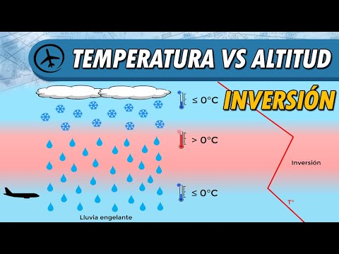
- Altitude inversions are also associated with freezing rain. When precipitation occurs in an area where the temperature is below 0 degrees Celsius (32 degrees Fahrenheit), it falls as snowflakes.
- However, if these snowflakes pass through an inversion where temperatures rise above freezing point, they melt into raindrops.
- If the raindrops then encounter sub-freezing temperatures below the inversion layer, they freeze upon impact with objects on the ground. This phenomenon is known as freezing rain.
Effects on Wind Patterns and Aircraft Performance
This section discusses how temperature inversions affect wind patterns and aircraft performance.
Wind Patterns
- Temperature inversions cause changes in vertical temperature gradients that influence wind circulation patterns.
- These changes can result in abrupt shifts in wind direction and intensity.
- The specific effects of these changes will be discussed further in future videos.
Aircraft Performance
- Increased air temperature associated with inversions reduces aircraft performance due to decreased air density.
- As aircraft ascend through an inversion from a colder region to a warmer one, their performance may be affected negatively.
Icing Conditions
This section explains how temperature inversions contribute to icing conditions for aircraft.
Freezing Rain and Icing
- Inversions play a role in creating icing conditions for aircraft. If an aircraft flies below an inversion layer where temperatures are below freezing point, it may encounter freezing rain.
- Freezing rain occurs when supercooled water droplets freeze upon impact with the aircraft, leading to ice accumulation.
- Flying in areas below an inversion can result in severe icing conditions.
Relationship between Temperature and Atmospheric Stability
This section highlights the relationship between temperature and atmospheric stability.
Temperature and Atmospheric Stability
- The behavior of temperature with altitude is closely related to atmospheric stability.
- A rapid decrease in temperature with altitude leads to atmospheric instability, resulting in turbulence, vertical cloud development, and thunderstorms.
- A slow decrease in temperature or the presence of an isothermal layer or inversion indicates atmospheric stability.
Conclusion
This section concludes the video by emphasizing the importance of understanding temperature inversions for analyzing weather phenomena and aviation operations.
Importance of Temperature Behavior
- The behavior of temperature with altitude has significant implications for weather analysis and aviation operations.
- Understanding temperature inversions helps predict wind patterns, turbulence, visibility conditions, and potential icing hazards.
- Further topics related to atmospheric stability will be covered in future videos.