Aprender español: Geografía de España (nivel básico)
Welcome to Tu escuela de español
The video introduces the topic of the geography of Spain.
Geography of Spain
- Spain is located in the northern hemisphere and is situated in the southwest of Europe.
- It has a total area of over 500,000 square kilometers.
- Spain occupies the majority of the Iberian Peninsula and shares borders with France, Andorra, Portugal, and Gibraltar. -
- The Iberian Peninsula is connected to the rest of Europe by the Pyrenees mountain range and is separated from Africa by the Strait of Gibraltar.
- Additionally, Spain has territories in Africa, including the autonomous cities of Ceuta and Melilla.
- The country also includes two groups of islands - the Balearic Islands in the east and the Canary Islands off the coast of Morocco.
Landscape and Mountains
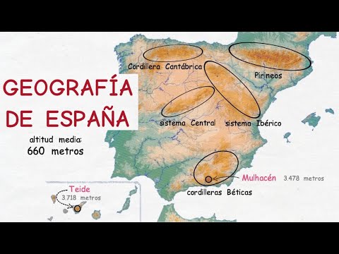
- Despite being known for its beaches, Spain has an average altitude of 660 meters and is one of Europe's most mountainous countries.
- It features five major mountain ranges - Pyrenees, Cantabrian Mountains, Central System, Iberian System, and Betic Mountains. -
- The highest mountain in Spain is Mount Teide (3,718 meters) on Tenerife Island in the Canary Islands, while the highest peak on the Iberian Peninsula is Mulhacén (3,478 meters) in Granada province.
Coastline and Rivers
- Spain has nearly 8,000 kilometers of coastline, including the Mediterranean Sea in the east, the Atlantic Ocean in the west (Galicia and Andalusia), and the Cantabrian Sea in the north. -
- The country's rivers are generally short and have low water flow due to limited rainfall. Important rivers include Ebro, Duero, Tajo, and Guadalquivir. -
Diverse Landscapes
- Spain boasts a diverse range of landscapes including beaches, mountains, plains, forests, lakes, and deserts. -