Explicación de Paralelos y Meridianos | Educatina
Exploring Geographic Elements: Parallels and Meridians
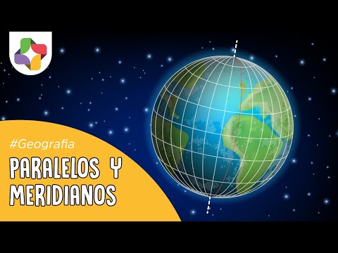
Introduction to Geographic Coordinates
- The video introduces the concept of geographic elements used for locating positions on Earth, focusing on parallels and meridians.
- It explains that these are imaginary lines covering the planet's surface, with parallels running east-west and meridians running north-south.
Characteristics of Parallels
- Parallels are described as circles with varying diameters; the maximum diameter is at the equator, while minimum diameters are at the poles.
- The equator is designated as the reference parallel (0 degrees), dividing Earth into northern and southern hemispheres.
- Values for parallels range from 0 to 90 degrees; in the northern hemisphere, values increase towards the North Pole, while they decrease (becoming negative) towards the South Pole.
Special Parallels
- The video discusses special parallels known as tropics, which mark solstice beginnings: Tropic of Cancer in the northern hemisphere and Tropic of Capricorn in the southern hemisphere.
- These tropics indicate significant solar positions on June 21 (summer solstice in the north) and December 21 (summer solstice in the south).
Understanding Meridians
- Meridians are also circular but have equal diameters converging at both poles. Each meridian has a corresponding anti-meridian when crossing hemispheres.
- The Prime Meridian, located at Greenwich, England, serves as a reference point marked at 0 degrees longitude.
Ranges of Meridian Values
- Meridian values range from -180 to +180 degrees; all western hemisphere meridians carry negative values while eastern ones hold positive values.
- This system helps define geographical locations relative to Greenwich's zero-degree line.
Conclusion